| Ownership: | Orano Canada Inc. option: Orano can earn a 51% interest by spending $3,000,000 on or before December 31, 2021 and can earn 70% interest by spending an additional $3,000,000 for a total of $6,000,000 on or before December 31, 2023. |
| Stage: | Highly Prospective; Drill Ready |
| Size: | 20,463 Ha |
| Location & Infrastructure |
Fir Island is located approximately 5km northeast of the community of Black Lake, on the northeast edge of the Athabasca Basin. It is connected by an all-weather road to the provincial highway system, which also provides year-round road access to the Rabbit Lake and McClean Lake mills. The property can be accessed by truck in the winter and by boat in the summer. |
| Regional Significance |
The regionally important Black Lake fault, part of the major Snowbird Tectonic Zone, transects the entire Athabasca Basin, and is highly prospective for unconformity-type uranium deposits. Cameco’s Centennial deposit is located along this Zone near the south side of the Athabasca Basin. The sandstone cover on the Fir Island project varies from 0 to 200m above the unconformity. The possibility of uranium mineralization below the unconformity at the base of the thrust fault (similar to McArthur River) or in the hanging wall of the Cathy Fault in the basement (similar to Millennium or Eagle Point) demonstrates the highly prospective nature of the Fir Island project. |
| Proximity to significant deposits |
The historic Nisto uranium mine (96 tonnes mined at 1.38% in the late 1950s) occurs in basement rocks on the northwest side of the Black Lake fault, directly adjacent to the property. The project is within driving distance of the McClean Lake mill, operated by Orano Canada Ltd. |
Outlook:
- Forum will be the exploration operator until such time as Orano has earned a 51% interest in the project.
Work Programs for 2021
- A diamond drill program was completed on the north side of the island in the area of the large resistivity anomaly, drilling along strike from the 6-hole drill fence completed in 2020. As at Janice Lake, the program had a late start due to the warm winter and the ice road wasn’t completed until the end of February. The two drills completed 10 holes for 3,051 metres, 3 holes investigating other targets to the south, and 7 holes investigating the resistivity anomaly, all on the island. The lake ice (unlike in 2015 when all holes were drilled on the ice) was not thick enough to support a drill hole being completed so the holes planned for the lake had to be delayed until better ice conditions are present. The three holes to the south returned background results, but the 7 holes in the resistivity low returned strong alteration, tectonization, quartz dissolution, boron enrichment (dravitic clays) and an offset of the unconformity ranging from 30 to 50 metres over a strike length of 1.4km. This target will be followed to the north in future exploration programs, where this fault system becomes marked with an EM conductor and joins the major Black Lake fault near the western shoreline. This program was 100% funded by Orano Canada Ltd.
Historical Work
- Forum completed a 10 hole reconnaissance drill program totaling 2,435m in early 2015, the first drill holes completed on this project. Drill hole FI-03 intersected 35m of 0.3% nickel from 180m to 215m in the basement lithologies. Drill hole FI-04 intersected up to 386ppm U in clay-rich basement lithologies immediately beneath the unconformity at 140m, and then 17m of enriched boron (up to 2810ppm) from 148m to 165m depth.
- Five holes were competed on two fences 50m apart ( See Target H on Figure 2) and intersected a very interesting area of tectonization, quartz dissolution, and a 50m offset in the unconformity along a NE trending thrust fault (Cathy Fault -See Figure 3). Dravite and sudoite clays were found in both the sandstone and basement lithologies, along with locally elevated geochemistry (U, Pb, B). Hole FI-8, drilled near the East Channel Structure, returned values of 137 and 161ppm U respectively, below a section of 16m of 2750ppm B, all within pegmatites starting at depth of 202m to the unconformity.
- Ground gravity surveys over the west channel (2015) and on the island (2016) have been completed. This was followed by a soil sampling program looking for anomalous indicator elements down-ice from the gravity lows. Very anomalous boron values were returned from several of the lows (Figure 2).
- In 2019 a resistivity survey was completed over the East Channel (located on the island) and showed a strong low interpreted to be due to alteration / tectonics on the north-west side (Figure 5).
- A 6-hole diamond drill program in 2020 completed one fence approximately 1km south of the 2015 drilling. The Cathy Fault was once again intersected, along with elevated geochemistry, strong alteration and tectonics and a 40m offset in the unconformity. The program was unfortunately cut short due to the Covid-19 situation, but a much larger drill program is planned for the winter of 2021.
Maps & Figures
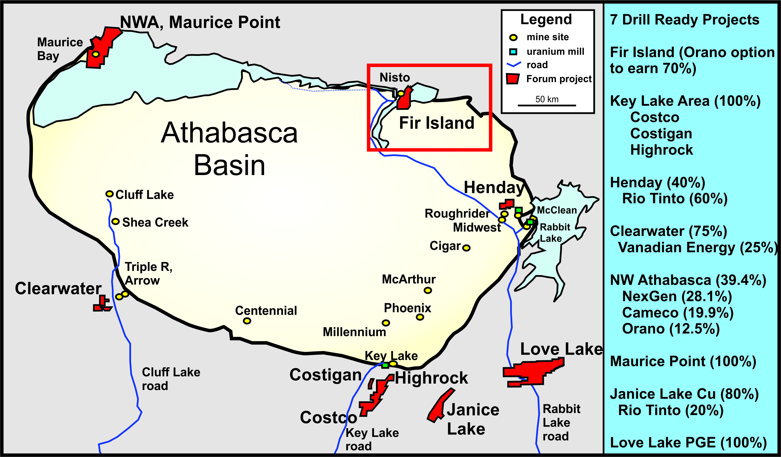
Figure 1: Fir Island Project Location Map. An all-weather road is present within 3km of the property and connects with the McClean Lake and Rabbit Lake uranium mills
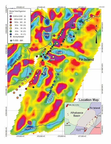
Figure 2: 2014 and 2016 Filtered Gravity Survey with Boron Geochemistry from Soil Samples
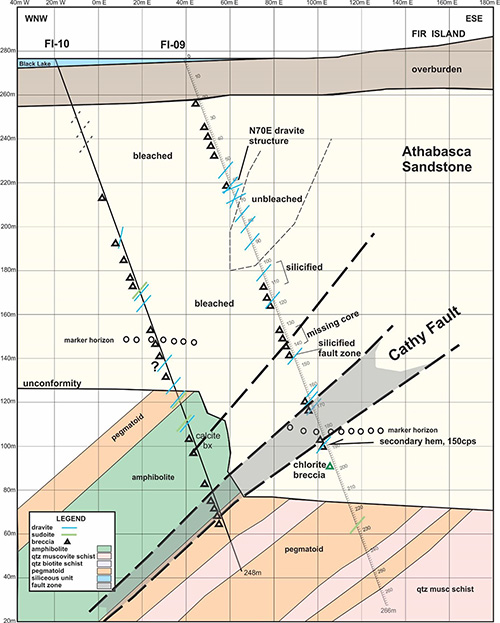
Figure 3: Cross-Section FI-9, 10. The extent of the Cathy fault into the basement rocks is not known. Blue lines are dravite intersections, triangles area tectonics.
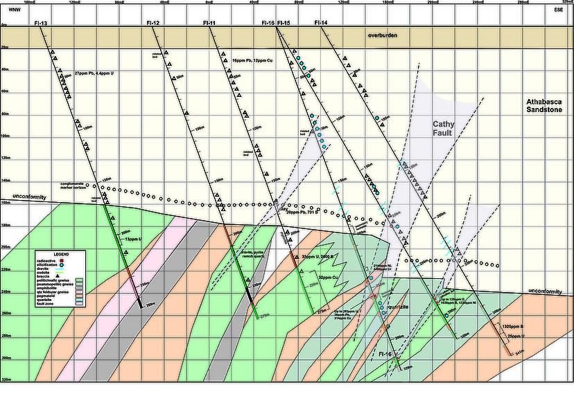
Figure 4: 2020 Drill Cross Section. The Cathy Fault appears to be steepening and may occur as a series of steps.
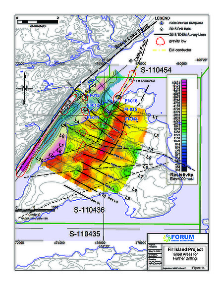
Figure 5: Resistivity Survey (2019) with Drill Hole Locations (2020) and Gravity Lows. Gravity lows are outlined in red, green colours represent the resistivity lows and dashed lines are interpreted faults.
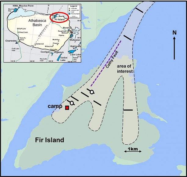
Figure 6: 2021 Drill area of interest. White dots are first hole locations for the two drills.